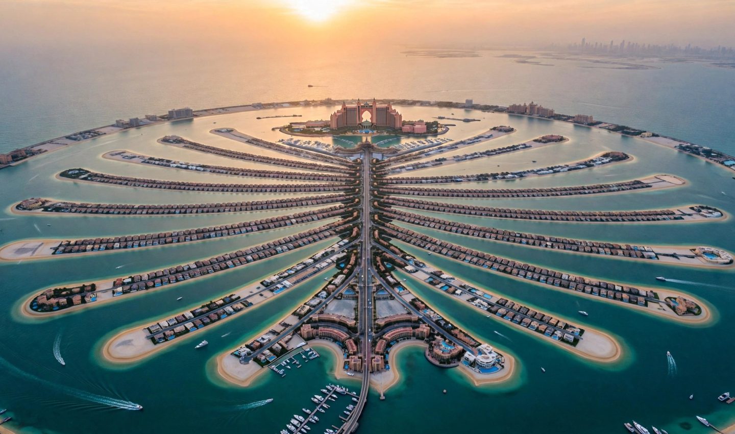
From the window of a plane, it is unmistakable: a palm tree drawn on the sea, so large and so precise it looks like a logo the ocean agreed to wear. Palm Jumeirah is the world’s largest man-made archipelago — the largest artificial island built in the sea — and it remains the single most audacious sentence in Dubai’s story.
An Island Built From Nothing
There was no island here. Between 2001 and 2006, the developer Nakheel simply made one: roughly 94 million cubic metres of sand, shaped into the outline of a palm tree, and 7 million tonnes of rock to armour and hold it. The palm shape is not decoration for its own sake — a trunk, a crown of fronds and a protective crescent around them maximised the amount of beachfront that could be created, and beachfront, in Dubai, is the whole point. Consider what those numbers mean: an entire new coastline, drawn first on a planner’s screen and then poured into the Gulf, grain by grain and rock by rock, until the sea had a tree growing in it.
Bigger Than 600 Football Pitches
The island covers 5.72 square kilometres of reclaimed land — bigger than 600 football pitches, laid out in the shape of a tree. An 11-kilometre crescent breakwater wraps around the fronds, calming the Gulf’s water so the shoreline inside stays gentle. And the Palm achieved the distinction every Dubai megaproject secretly wants: it is visible from space, a drawing on the surface of the Earth clear enough to be read from orbit. Plenty of cities have landmarks. Very few have altered the map itself — the coastline of Dubai, as drawn in any atlas today, includes a tree that did not exist at the turn of the century, because it had not been invented yet.
📸 Follow @dxbtalk1 on Instagram for daily Dubai in photos →
Life on the Palm
Today the island is a fully lived-in world. Thousands of villas and hotels call it home, and two of the most famous resorts on Earth stand here: Atlantis, The Palm, the rosy, fantastical original, and Atlantis The Royal, its ultra-luxury successor — two different eras of Dubai ambition within sight of each other. The Palm Monorail runs up the trunk, carrying visitors along the island’s spine. What was an engineering diagram in 2001 is now a neighbourhood with its own skyline, its own rhythm and its own sunset views — all of it standing on 5.72 square kilometres of land that used to be seafloor. There is a quiet strangeness to ordinary life here that residents stop noticing and visitors never quite get over: every school run, every morning coffee, every jog along the crescent happens on ground that did not exist a generation ago, in the shape of a tree, in the middle of the sea. The Palm did not just add land to Dubai — it added a symbol the whole world recognises on sight.
Free Dubai Tools
Dubai, in Your Hands
Practical Notes
The easiest way to grasp the Palm’s shape is from the air, or from the Palm Monorail, which runs up the trunk and gives you the island’s geometry at street level, with the fronds spreading out on either side. The island covers 5.72 square kilometres, so it is bigger than it looks on the map — allow proper travel time between the trunk, the fronds and the crescent. Atlantis, The Palm and Atlantis The Royal anchor the resort end of the island, while the fronds are largely residential, best admired from the water or the monorail. And if your flight into Dubai arrives in daylight, watch the window: the view from above is the one this island was designed for.
DXB FACT — DID YOU KNOW?
Snow in the middle of the desert
- Ski Dubaithe Middle East's first indoor ski resort
- Real snow22,500 m² of it
- Inside temperature−1°C to −4°C, all year
- Slopes5 — including an indoor black run
Source: The National
A new Dubai fact every dayRead more »
Reader poll
Poll of the Day
A fun reader poll, just for curiosity — not an official survey. A new question arrives every day.